Home | About Us | Contact Us
Automated Engineering Technologies Ltd.
- Company Profile
- Services
- Aerial Imaging

- Construction Layout
- Topographic Surveys
- Site Plans
- Volume Surveys
- Utilities
- 3D Rendering
- Drafting Services
Aerial Imaging Solutions
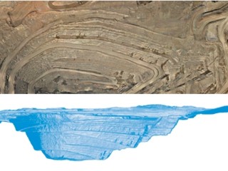
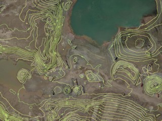
Using Unmanned Aircraft Systems (UAS), we are able to collect large amounts of data (several square kilometers) in a short period of time from a safe location.
With leading edge data acquisition, we are able to quickly collect a high quality photo image and accurate surface data.
The collected data can be utilized to produce topographical base plans, site plan and route planning, process monitoring, volume calculations, disaster analysis and as-built information.
Project Types:
- Subdivision Planning & Design
- Roadway Route Planning
- Utility Corridor Planning
- Excavation and Volume Calculations
- Open Pit Mining Plans and Volumes
- Agricultural Mapping
- Conservation Area Mapping
- Drainage Area Mapping
- Define Features of Interest
- Construction Progress Photos
Deliverables:
- Orthophotos
- Contour Mapping
- Three-Dimensional (3D) Photos
- Point Clouds
- Triangulated Irregular Networks (TIN)
- Digital Surface Models (DSM)
Click Here for the Brochure
Click Here for a Contour Sample
Note: They are large files and may take a while to open